What is underground utility mapping and why does it matter?
Underground utility mapping turns information about buried services into a usable record of what is believed to be beneath a work area. Rather than simply marking a cable or pipe on the ground, mapping brings together available plans, site observations, locating results, survey data and, where required, physical verification so project teams can understand how underground infrastructure relates to the proposed works.
This distinction matters. A locator may identify the likely alignment of a service at several points, while a utility map records those findings in a form that can support design, excavation planning, coordination and future site decisions. The quality of that map depends on the quality of the information used to create it, so mapped lines should never be treated as equally certain unless their source and level of verification are understood.
What is underground utility mapping?
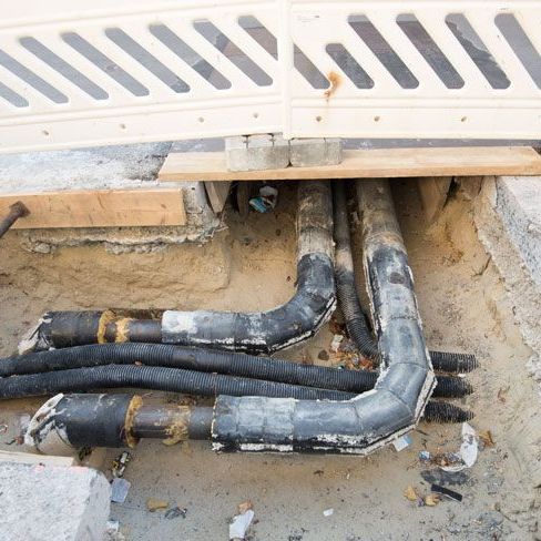
Underground utility mapping is the process of recording the location and relevant attributes of buried infrastructure in a plan, drawing or digital spatial dataset. Depending on the project scope, the resulting information may show power, communications, gas, water, sewer, drainage, conduits, ducts and other underground services.
A useful utility map can include more than a coloured line showing an approximate route. It may also record service type, horizontal alignment, depth information where available, surface features, inspection points, known connections, survey coordinates, notes about the locating method and information about how confidently the service position has been established.
Smooth Flow Hydro provides utility mapping services as part of its broader underground service locating capability across Adelaide and regional South Australia.
How is an underground utility map created?
Utility mapping is normally a staged investigation. The exact sequence varies with the site, the buried assets and the level of information required, but several sources of evidence are commonly combined.
1. Existing plans and records are reviewed
The starting point is usually the information already available about the site. This can include Before You Dig Australia plans, asset-owner drawings, previous surveys, as-constructed records, site plans and historical project documentation.
These records help identify which infrastructure owners may have assets in the work area and where services are expected to run. They are valuable planning information, but they should not automatically be treated as a precise representation of current underground conditions. Services may have been altered, records can vary in accuracy and some privately owned infrastructure may not appear in the available plans.
2. The site is inspected for physical clues
Surface features can provide important context for underground records. Pits, valves, hydrants, meter boxes, cabinets, access chambers, marker posts, kerb markings and visible service entries can all indicate how buried infrastructure may continue through the site.
SafeWork SA includes visual site inspection as part of its guidance for locating underground utilities. Comparing physical evidence with the available plans can reveal inconsistencies or areas that require further investigation before excavation proceeds.
3. Electronic locating equipment is used where suitable
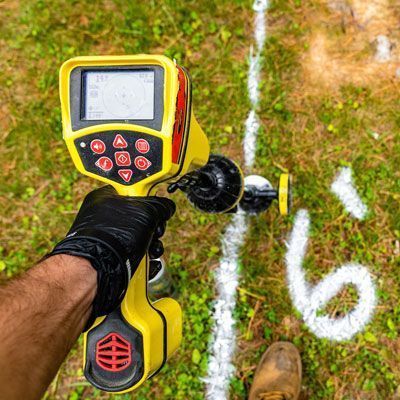
Electromagnetic locating is commonly used to trace conductive underground services such as many power, telecommunications and metallic pipe systems. The locator identifies and follows a signal associated with the service, allowing its likely alignment to be marked and recorded.
Where additional subsurface information is required, ground penetrating radar can also form part of the investigation. GPR records reflections from changes beneath the surface and can assist with locating some metallic and non-metallic targets. Its effectiveness varies with ground conditions, target size, depth, moisture and the contrast between the target and surrounding material, so it should not be treated as a method that can identify every buried service in every situation.
For a broader overview of the locating stage, Smooth Flow Hydro's utility locating services support civil and commercial projects that need buried infrastructure investigated before digging.
4. Critical services may be physically verified
Where the exact position of a service is important to the proposed work, locating data may need to be followed by physical verification. Targeted potholing can expose the asset at selected points so its actual depth and position can be directly observed and measured.
Hydro vacuum excavation is one method that may be used for potholing where permitted by the relevant asset owner and suitable for the site. Smooth Flow Hydro provides utility excavation services for controlled exposure around buried infrastructure.
5. The findings are captured and mapped
Once services have been identified, the relevant positions and attributes can be recorded into the project mapping or survey system. Depending on the required deliverable, this may be a marked site plan, CAD drawing, GIS dataset, survey output or another project-specific format.
The important point is that the map should preserve the context behind the data. A service identified from an old plan does not carry the same level of certainty as one physically exposed and directly measured. Recording the source and quality of the information helps designers, supervisors and excavation crews understand what is known and where uncertainty remains.
What is the difference between utility locating and utility mapping?
Utility locating and utility mapping are closely connected, but they are not the same task. Locating is the investigation used to determine where an underground service is likely to be. Mapping is the process of recording and organising that information so it can be used by the wider project team.
For example, an electromagnetic locator may trace an underground cable across a site and mark its alignment on the surface. Mapping can then capture that alignment into a drawing or spatial dataset together with the service type, depth information where available, survey position and notes about how the location was established.
On more complex projects, several locating methods may feed into one map. Plans, electronic locating, GPR, surface features and pothole measurements can all contribute different levels of information about the same underground network.
What information can a utility map include?
The required content depends on the project, but an underground utility map may include:
- the approximate or surveyed alignment of buried services
- service type, such as electricity, communications, gas, water, sewer or drainage
- depth or level information where it has been obtained
- pits, valves, chambers, hydrants and other associated surface features
- known connection or crossing points
- survey coordinates or spatial reference information
- the locating or verification method used
- quality or confidence information associated with each service
- notes identifying unresolved or uncertain features
- the date the information was collected or verified
This additional context is particularly important on congested sites. A plan showing several services crossing the same construction corridor is more useful when the team can distinguish between approximate record information and assets that have been located or physically verified on site.
Why does utility mapping matter during design?
Design decisions can be affected long before excavation starts. Foundations, drainage, new utility routes, pits, retaining structures, directional drilling alignments and other project elements may need to be positioned around existing underground infrastructure.
A site-specific utility map gives designers a clearer picture of the constraints beneath the proposed work area. This can support earlier identification of potential clashes, help determine where additional investigation is required and reduce reliance on assumptions made from schematic asset plans alone.
It is important, however, to match the certainty of the utility information to the design decision being made. If a proposed footing or bore passes very close to a buried service, approximate mapping may not provide enough confidence. Further locating or physical verification may still be required before the design is finalised.
Why does utility mapping matter before excavation?
SafeWork SA states that businesses undertaking excavation work must take reasonable steps to obtain current underground essential services information relating to the excavation area and adjacent areas before work begins. That information includes the services that may be affected, the location and depth of associated pipes, cables or plant and any conditions applying to the proposed excavation.
Utility mapping can help organise that information into a form that is easier to apply to the actual work area. Excavation crews can compare the proposed trench, footing, bore or pit with the mapped service alignments and identify where additional controls, potholing or changes to the excavation sequence may be required.
Mapping does not eliminate utility-strike risk and should not replace site-specific excavation controls. Its value is in improving the information available to the project team before ground is broken and keeping that information connected to the work being planned.
How does AS 5488 relate to underground utility mapping?
Australia uses AS 5488.1:2022, Classification of Subsurface Utility Information , as a framework for classifying information about underground utilities. The standard recognises that subsurface information can come from different sources and methods, and that the quality of that information should be communicated to the people who use it.
This is particularly relevant to utility mapping because a single drawing may contain information with very different levels of certainty. Records and desktop information can help indicate where a service may exist, electronic detection can provide stronger site-based evidence and direct visual exposure allows the service to be measured at the point where it is uncovered.
For project teams, the practical lesson is straightforward: do not treat every mapped utility line as equally exact. The source, method, date and level of verification should be considered when deciding whether the information is sufficient for design or excavation.
Is a utility map the same as a Before You Dig plan?
No. Before You Dig Australia provides a referral service that connects people planning work with participating infrastructure owners so they can receive relevant asset plans and information. These plans are an important starting point for identifying which networks may be present in the work area.
A site-specific utility map can go further by incorporating field investigation carried out for the actual project. Electronic locating, GPR, visual evidence, potholing and survey capture may all add information that is not available from asset-owner records alone.
BYDA also notes that not every asset owner is a member of its service. Private utilities, undocumented infrastructure and changes made since older records were prepared are additional reasons to treat plans as one source of information within a broader locating process.
When should underground utility information be updated?
A utility map represents the information available when the investigation was completed. Site conditions can change. New services may be installed, existing assets can be relocated, earthworks can alter surface levels and new construction can affect access to previously mapped features.
Before relying on an older utility map, project teams should consider when it was prepared, what methods were used, whether the site has changed and whether the map was created for the same work area and purpose. Current BYDA information and additional field locating may be required before a new excavation begins.
Keeping the date and source of mapped information with the deliverable makes it easier for future users to understand what the map represents and whether further investigation is appropriate.
Underground utility mapping across South Australia
Smooth Flow Hydro provides underground service locating, utility mapping, hydro excavation and non-destructive digging support for civil, commercial and infrastructure projects across Adelaide and regional South Australia. The appropriate approach depends on the assets present, the information already available and the level of certainty required for the proposed work.
Need a clearer picture of the services beneath your project site? Contact the Smooth Flow Hydro team with the site location, proposed work area and available utility information to discuss the locating and mapping requirements.
For further excavation guidance, review Before You Dig Australia and SafeWork SA's excavation work guidance.